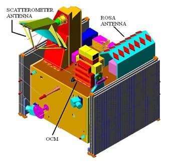
Resourcesat Satellite
ResourceSat Satellite Resourcesat Satellite (IRS-P6) is an advanced Remote Sensing satellite built by Indian Space Research Organization (ISRO). Resourcesat Sensor Specifications: Sensor AWiFS LISS-3 Number of Bands 4 4 Spectral Band 2 (µ) 0.52 – 0.59 (green) 0.52 – 0.59 (green) Spectral Band 3 (µ) 0.62 – 0.68 (red) 0.62 – 0.68 (red) Spectral Band […]