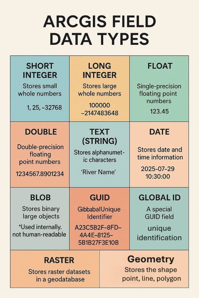
GIS Data

GIS integrates many different kinds of data layers using spatial location. Most data has a geographic component. GIS data includes imagery, features, and basemaps linked to spreadsheets and tables.

ArcGIS Field Data Types

ArcGIS Data Types

ArcGIS Field Data Types ArcGIS Data Types In ArcGIS, data types are critical for managing spatial and attribute information. ArcGIS supports a variety of data types broadly categorized into spatial (geographic) and non-spatial (attribute or tabular) data. File Geodatabase are the same as data types. ArcGIS Field Data Types When you create or manage an […]

ArcGIS Data Types Read More »

GIS Data Types

GIS Data Types

Types of GIS Data GIS Data Types GIS (Geographic Information System) data can be broadly classified into three main types, each with its own subtypes: Spatial Data (Geospatial Data) There are two different types of Spatial data, I) Vector data and II) Raster data. Each type of data has its own format. Vector Data Vector

GIS Data Types Read More »

ArcGIS Open Data

ArcGIS Open Data

ArcGIS Open Data: Download Data From ESRI Open Data Hub Introduction ArcGIS Open Data is a free capability of ArcGIS Hub that allows governments, organizations, and communities to share authoritative geospatial data with the public via customizable websites. The Open Data enables all types of GIS data formats, its Vector and Raster data. Open data

ArcGIS Open Data Read More »

SRTM Data

SRTM Data

SRTM- Shuttle Radar Topography Mission On 23 September 2014, the White House announced that the highest-resolution topographic data generated from NASA‘s that is Shuttle Radar Topography Mission (SRTM), it was released globally by late 2015. The Shuttle Radar Topography Mission is elevation data on a near-global scale, acquired from the Space Shuttle, to generate the

SRTM Data Read More »

Digital Elevation Model-DEM data

Download DEM

Digital Elevation Model (DEM) Download Digital Elevation Model (DEM) widely known as a Digital Terrain Model (DTM). A DEM can be used to create topographic maps of overland terrain, as well as bathymetric maps. A DEM data can be represented as a raster dataset, or as a vector-based Triangular Irregular Network (TIN). Best 6 Free

Download DEM Read More »

Scroll to Top