Remote Sensing

Remote sensing (RS) is an art and science of obtaining information about physical characteristics of an area by measuring its reflected and emitted radiation at a distance to help of Satellite or Aircraft.

In below list of Remote sensing Analysis Tutorial.

Remote Sensing Software

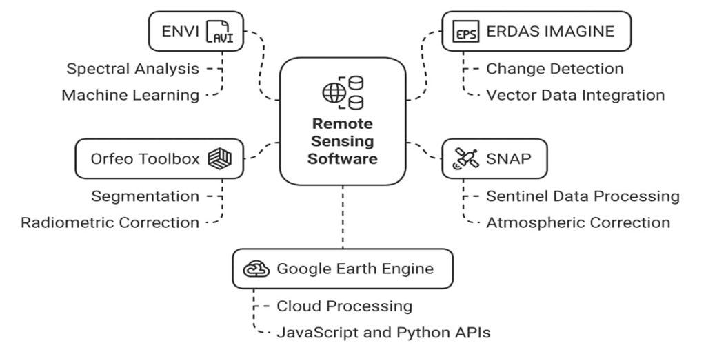
Summary: – Remote Sensing software is designed to process, analyse, and visualize data sensors capture on satellites, drones, or aircraft. Discuss 10 best Remote sensing software’s, and their features, advantages and disadvantages. A Complete Overview of Remote Sensing Software Remote sensing software is mainly used to work with images taken by satellites, drones, or aircraft. […]

Remote Sensing Software Read More »

Google Earth Web

Explore Google Earth Web What is the Google Earth Web? Google Earth Web is an advance Earth version to explore worldwide satellite imagery and 3D buildings and terrain. Earth Google Web is the world’s most detailed globe. It’s offer to create your own project, Download and Share with anyone. How to Use Google Earth Web?

Google Earth Web Read More »

Metadata in GIS

Metadata in GIS

Metadata in GIS & Remote Sensing What is Metadata? Metadata is basically textual data that describes data. It often includes elements such as data creation date, history of the data, data type, and common usages of the data. Digital Geographic data is an attempt to model and describe the real world for use in computer

Metadata in GIS Read More »

Digital Image Processing in Remote Sensing

Digital Image Processing

Digital Image Processing: Remote Sensing A Digital Image is a representation of a two-dimensional image as a finite set of digital values, called picture elements or pixels. Pixel values typically represent gray levels, colors, heights, opacities etc. Digitization implies that a digital image is an approximation of a real scene. Digital image processing (DIP) focuses

Digital Image Processing Read More »

Scroll to Top