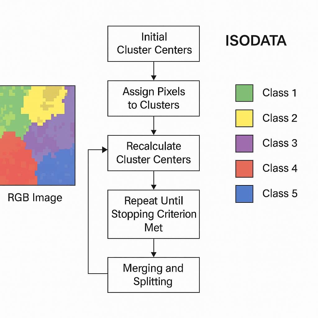
Remote Sensing

Remote sensing (RS) is an art and science of obtaining information about physical characteristics of an area by measuring its reflected and emitted radiation at a distance to help of Satellite or Aircraft.

In below list of Remote sensing Analysis Tutorial.

ISODATA

ISODATA

ISODATA ISODATA is an iterative Self-Organizing Data Analysis Technique. What is ISODATA? The ISODATA algorithm stands for Iterative Self-Organizing Data Analysis Technique. It is an unsupervised classification method used primarily in remote sensing and image processing for clustering multispectral image data. It uses spectral distance between image pixels in feature space to classify pixels into […]

ISODATA Read More »

thermal infrared

Thermal Infrared

Thermal Infrared Remote Sensing What is Thermal Infrared? Thermal Infrared (TIR) is an energy heat, Remote Sensing records the radiant temperature of the object. TIR refers to a portion of the electromagnetic spectrum that detects heat emitted by objects, rather than reflected sunlight. It typically covers Wavelength of between 3 and 20 micrometers (nm). Characteristics

Thermal Infrared Read More »

IKONOS Satellite image

IKONOS Satellite

IKONOS Satellite IKONOS Satellite was launched in September 1999. IKONOS panchromatic Sensor resolution is 1 m, and multispectral scanner resolution is 4 m. The swath width is 13 km at nadir. Accuracy with out ground control is 12 m horizontally, and 10 m vertically; with ground control it is 2 m horizontally, and 3 m

IKONOS Satellite Read More »

QuickBird Satellite

QuickBird

QuickBird Satellite QuickBird Satellite was launched in 2001, by Digital Globe offering imagery for map publishing, land and asset management, change detection and insurance risk assessment. The QuickBird produces sub-meter resolution Panchromatic and Multispectral imagery. The data collection nominal swath width is 16.5 km at nadir, and areas of interest sizes are 16.5 km x

QuickBird Read More »

Scroll to Top