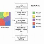
Supported Raster and image Data formats
| Raster/Image Data Format |
|---|
| ADS |
| Advanced Spaceborne Thermal Emission and Reflection Radiometer (ASTER) |
| AIRSAR Polarimetric |
| Applanix DSS |
| ARC Digitized Raster Graphics (ADRG) |
| ASCII Grid |
| Band interleaved by line (BIL), band interleaved by pixel (BIP), band sequential (BSQ) |
| Bathymetric Attributed Grid (BAG) |
| Big TIFF |
| Binary Terrain (BT) |
| Bitmap (BMP), device-independent bitmap (DIB), or Microsoft Windows bitmap |
| BSB |
| Committee on Earth Observation Satellites (CEOS) Synthetic Aperture Radar (SAR) |
| Compressed ARC Digitized Raster Graphics (CADRG) |
| Controlled Image Base (CIB) |
| Cloud Raster Format (CRF) |
| Deimos-2 |
| Digital Geographic Information Exchange Standard (DIGEST) ARC Standard Raster Product (ASRP), UTM/UPS Standard Raster Product (USRP) |
| Digital Image Map (DIMAP) |
| Digital Terrain Elevation Data (DTED) Level 0, 1, and 2 |
| DMCii Satellites |
| DubaiSat-2 |
| Earth Resources Laboratory Applications Software (ELAS) |
| Enhanced Compressed Raster Graphic (ECRG) |
| Enhanced Compressed Wavelet (ECW) |
| ENVI Header Format |
| Envisat Image Product (ESAT) |
| EOSAT FAST |
| ER Mapper |
| ERDAS 7.5 GIS |
| ERDAS 7.5 LAN |
| ERDAS IMAGINE |
| ERDAS RAW |
| Esri Grid |
| Esri Grid stack |
| Esri Grid stack file |
| Extensible N-Dimensional Data Format (NDF) |
| File geodatabase raster |
| Floating-point raster file |
| FORMOSAT-2 |
| GDAL Virtual Format (VRT) |
| GeoEye satellite |
| GF-4 |
| Graphic Interchange Format (GIF) |
| Grid eXchange File (GXF) |
| GRIB |
| Golden Software Grid (.grd) |
| Heightfield raster (HF2) |
| HGT |
| Hierarchical Data Format (HDF) 4 and 5 |
| High Resolution Elevation (HRE) |
| IDRISI Raster (RST) |
| IKONOS satellite |
| ILWIS Raster Map |
| Image Display and Analysis (IDA) |
| Image service (from ArcGIS Server) |
| Image service definition (.ISDef) |
| Image service reference (.ISRef) |
| Integrated System for Imagers and Spectrometers (ISIS) |
| Intergraph raster files: CIT—Binary data; COT—Grayscale data |
| ISAT |
| Japanese Aerospace Exploration Agency (JAXA) PALSAR |
| Jilin-1 |
| Joint Photographic Experts Group (JPEG) File Interchange Format (JFIF) |
| JPEG 2000 |
| KOMPSAT-2 |
| KOMPSAT-3 |
| Landsat satellites (1–8) |
| LAS (Lidar data files) |
| LAS dataset |
| Magellan MapSend BLX/XLB format |
| MAP |
| Map service (from ArcGIS Server or ArcGIS.com) |
| MATCH-AT |
| Meta Raster Format (MRF) |
| Multi-Resolution Seamless Image Database (MrSID) |
| MrSID (MG4) Lidar |
| National Imagery Transmission Format (NITF) |
| National Land Archive Production System (NLAPS) |
| New Labeled USGS DOQ (DOQ2) |
| NITF Version 2.1 Commercial Dataset Required Document (NCDRD) |
| NOAA Polar Orbiter Level 1b Data Set (AVHRR) |
| OrbView-3 satellite |
| PCI .aux Labelled Raw Format |
| PCIDSK |
| Personal geodatabase raster |
| Planetary Data System (PDS) |
| Pleiades |
| Portable Network Graphics (PNG) |
| QuickBird satellite |
| RADARSAT-2 satellite |
| RapidEye satellite |
| Raster catalog |
| Rasters in enterprise geodatabases |
| Raster process definition (.RPDef) |
| Raster Product Format (RPF) |
| SAGA GIS Binary Grid |
| Sandia Synthetic Aperture Radar (GFF) |
| Sentinel-1 |
| Sentinel-2 |
| Shuttle Radar Topography Mission (SRTM) |
| SOCET SET |
| Spatial Data Transfer Standard (SDTS) digital elevation model (DEM) |
| SPOT satellites |
| Tables |
| Tagged Image File Format (TIFF) |
| Terragen terrain |
| Terrain |
| TerraSAR-X |
| United States Geological Survey (USGS) digital elevation model (DEM) |
| Unmanned aerial vehicle/Unmanned aerial system (UAV/UAS) |
| USGS Digital Orthophoto Quadrangles (DOQ) |
| Web Coverage Service (WCS, OGC standard) |
| Web Map Service (WMS, OGC standard) |
| WorldView satellites |
| X PixMap (XPM) |
Pages: 1 2