An Overview of Drone-Based Photogrammetry Techniques and its Real-World Application
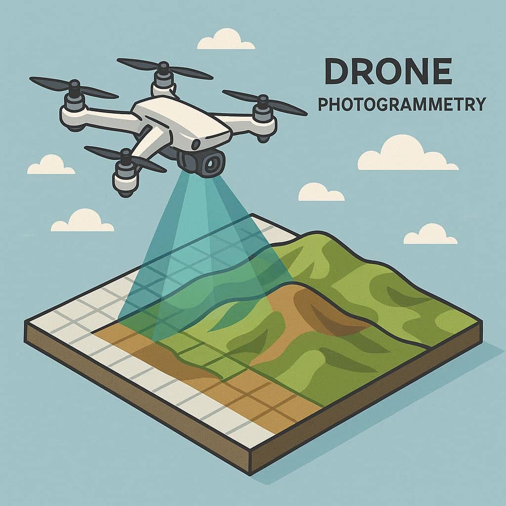
In drone photogrammetry, a drone captures high resolution aerial images, which then can be processed by various Photogrammetry software to become accurate, detailed 3D models and 2D maps.
Indroduction
Drone photogrammetry is the science of using aerial images captured by drones to create detailed and accurate 2D maps and 3D models of physical landscapes and structures. It has become common and one of the highly demanding sectors as capturing images using drone will give more accurate and clear data.
Things to Keep in Mind for Drone Photogrammetry
Overlapping images: It’s important that your drone captures overlapping images to provide multiple perspectives of the same spot on the ground. Think of it as capturing the same point from two different angles, much like how our two eyes perceive depth.
Flight pattern: Some drones allow you to use present flight patterns to make sure you get enough high-resolution overlapping images for your 3D model. If your drone can’t fly like this automatically using a present mode, make sure you’ve thought out your flight path, so you get enough overlapping images to make your 3D model.
Altitude matters: Remember—the farther you are from the ground, the lower your resolution will be, and vice versa. Flying high can allow you to cover an area more quickly, but that speed will come at the cost of lower quality. This is why altitude is an important consideration when planning a photogrammetry mission with a drone.
Processing: The quality of your final result will be determined not just by the quality of the data you collect, but also by the quality of the software you use.
Lighting: Aim for midday flights with vertical sunlight for clear images and avoid early and late-day flights to minimize horizontal shadows.
Camera Angles— Nadir vs. Oblique
Nadir imagery: A nadir camera angle means the camera is perpendicular to the ground. Nadir imagery is best for flat terrains.
Oblique imagery: An oblique camera angle means the camera is angled rather than perpendicular. Oblique imagery is ideal for modeling vertical structures.
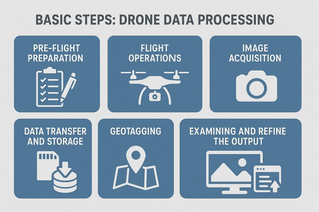
Basic Steps- Drone Data Processing
- Pre-flight preparation: The drone automatically performs a pre-flight check to ensure that the drone is in working condition. This includes checking battery power, verifying proper sensor function, and confirming that the camera settings are appropriate for the desired output.
- Flight operations: The operator launches the drone and remotely controls its flight. The drone follows a pre-determined flight plan that outlines the area to be covered and the flight path. Parameters such as altitude, speed, and image overlap is considered when planning the flight.
- Image acquisition: During the flight, the drone captures a range of images from different angles and perspectives. The goal is to obtain a comprehensive set of photographs that cover the entire area of interest. These images serve as the raw data for the photogrammetric process.
- Data transfer and storage: Once the image acquisition is finished, the captured images are transferred and stored securely. They are usually downloaded from the drone’s memory or storage device to a computer or another data storage medium. Drone takes measures to ensure that the data is safely transferred and backed up, minimizing the risk of any loss or damage.
- Geotagging: The images obtained from the ground is geotagged using various like Elmid studio, red toolbox etc. This helps in assigning the coordinates in turn the location information to each image. This is optional to do in a separate software as the geotagged images can be obtained from the drone itself.
- Data processing: After the initial data processing, further post-processing and analysis may be performed. Drone data is compatible with mainstream post processing software on the market. The photogrammetry software is used to stitch the images together. Using this we can generate the point cloud, depth maps, Ortho mosaic and 3D models.
- Examining and refine the output: The 3D model that has generated for inconsistencies or gaps in the data should be examined. We can use the assign image option to patch up the blur images.
- Exporting the data: Once the desired output generated, it should be exported in the required format.
The Ground Control Points (GCP’s) are taken during the survey for more accurate data.
Drone image processing software converts raw aerial images captured by drones into 2D maps, 3D models, and other spatial data for various applications. Popular options include Pix4D Pix4D, Agisoft Metashape, DJI Terra, DroneDeploy, and Open Drone Map.
Applications
Drone photogrammetry is commonly used in several industries these days. Here are some of the top ones.
Agriculture and Farming
Farmers and agronomists are using drone photogrammetry to monitor crops, assess health, and optimize yields.
By creating detailed 3D maps, farmers can detect issues like poor drainage, pest infestations, or areas of low fertility. And by analysing crops at various stages, farmers can make informed decisions about irrigation, fertilization, and harvesting.
Construction
In construction, drone photogrammetry can help with site planning, monitoring progress, and ensuring that projects remain on schedule.
Detailed 3D models provide stakeholders with a clear view of the terrain and existing structures, helping to design and place new constructions.
Real Estate
In real estate, aerial visuals can provide potential buyers with a view of an entire property, proving especially valuable for larger estates or buildings, or in cases where prospective buyers aren’t able to visit the property in person.
Archaeology and Historic Preservation
Historians and archaeologists have been using drone photogrammetry to document and preserve ancient sites for a while now.
The technique offers a non-invasive way to study areas of interest, creating detailed models that can be analysed without physically disturbing the site—a consideration that’s especially important for sites that are deteriorating or at risk of damage.
Mining and Quarrying
By regularly mapping a mine or quarry with drone photogrammetry, operators can track changes, calculate volumes, and plan extractions more safely and efficiently. Drone data can also help optimize the extraction processes, monitor equipment, and ensure worker safety.
Environmental Monitoring and Conservation
Environmentalists can use drone photogrammetry for a range of purposes, from mapping erosion on coastlines to tracking deforestation in remote jungles. The detailed data you get from drone imagery can help with monitoring a variety of sensitive ecosystems, understanding changes, and planning conservation efforts more effectively.
Disaster Response and Management
In the aftermath of natural disasters like floods, earthquakes, or hurricanes, swift response is crucial. Drone photogrammetry provides emergency responders with up-to date 3D maps of impacted areas, helping to coordinate relief efforts, assessing damage, and planning recovery operations.
Conclusion
Drone photogrammetry is a powerful tool that offers a cost-effective and efficient way to collect detailed aerial data for various applications. It’s becoming increasingly popular due to its ability to capture high-resolution imagery and create accurate 3D models.