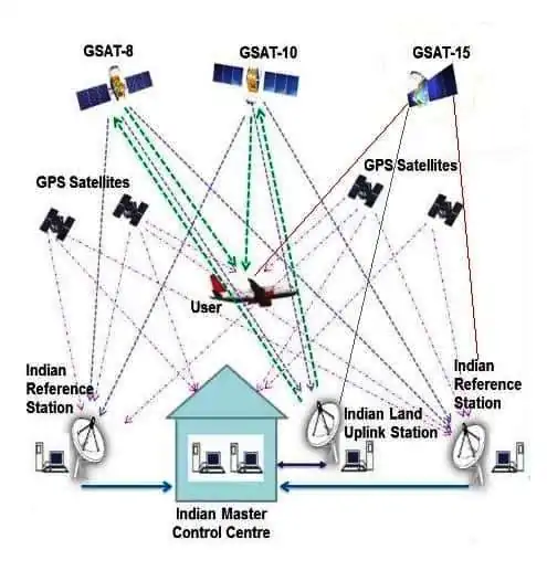
GISRSStudy » GNSS System » Page 2

GNSS System

Global navigation satellite system (GNSS) is a general term describing any satellite constellation that provides positioning, navigation, and timing services on a global or regional basis.

GAGAN

GAGAN – GPS Aided GEO Augmented Navigation Introduction GAGAN GAGAN (GPS Aided GEO Augmented Navigation) is a Space Based Augmentation System (SBAS) developed by ISRO (Indian Space Research Organization) and AAI (Airports Authority of India). It is to provide the best possible navigational services over Indian Air Space. GAGAN is a system of satellites and ground stations that provide GPS signal corrections, giving […]

GAGAN Read More »

DGPS

DGPS – Differential Global Positioning System What is DGPS? A DGPS stands for Differential Global Positioning System. It is an enhancement to the Global Positioning System (GPS) which provides improved location accuracy, in the range of operations of each system, from the 15-meter nominal GPS accuracy to about 1–3 centimeters. Each DGPS uses a network

DGPS Read More »

How Does GPS Work

GPS The GPS stand for Global Positioning System, it is a satellite-based navigation system owned by the United States government and operated by the United States Space Force. It’s formed from a constellation of 24 satellites. GPS works in any weather conditions, anywhere in the world, 24 hours a day. In 1973 the U.S. Department

How Does GPS Work Read More »

GNSS

GNSS (Global Navigation Satellite System) GNSS stand for Global Navigation Satellite System. It is a general term describing any Satellite constellation that provides positioning, navigation, and timing services on a global or regional basis. Global Navigation Satellite System (GNSS) which is basically a constellation of constellations of systems like NAVSTAR GPS and GLONASS, wherein the

GNSS Read More »

Scroll to Top