GIS

GIS (Geographic Information System) is a framework to organize, communicate, and understand the science of our world. GIS integrates many types of data. It analyzes spatial location and organizes layers of information into visualizations using maps and 3D scenes. Every field are using GIS to make maps that communicate, perform analysis, share information, and solve complex problems around the world.

In below list of GIS Analysis Tutorial.

ArcGIS Geocoding labeled point

ArcGIS Geocoding

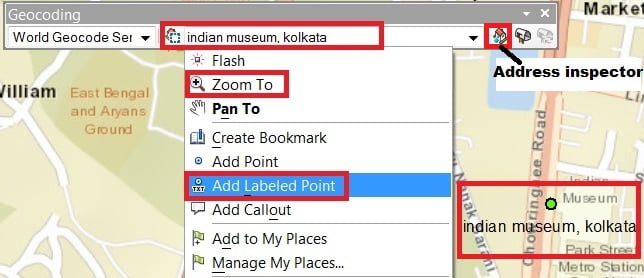
Geocoding in ArcGIS What is Geocoding? Geocoding is the process of transforming text-based address descriptions into geographical coordinates. Geocoding also known as Georeferencing, is the geographical registration or coding of the pixels in an image. Geocoded data are images that have been rectified to a particular map projection and pixel size. Types of Geocoding: Create […]

ArcGIS Geocoding Read More »

Geodatabase

Geodatabase

Getting Started with Geodatabase in ArcGIS: A Beginner’s Guide In this Tutorial Learn, how to create a Geodatabase in ArcGIS. What is a Geodatabase? A Geodatabase (GDB) is a Database designed to store, query, and manipulate geographic information and spatial data. It’s like a digital container that holds all the different types of map-related information

Geodatabase Read More »

GIS Companies in India

GIS Companies in India

GIS Companies in India Best GIS Companies Jobs in India 2025 List of GIS Company in India’s Major Cities GIS Companies in Ahmedabad GIS Companies in Chennai GIS Companies in Delhi GIS Companies in Hyderabad GIS Companies in Kolkata GIS Companies in Mumbai GIS Companies in Pune

GIS Companies in India Read More »

GIS Companies

GIS Companies

GIS Companies in Top Countries Best GIS Companies in the world Countries List of Best GIS Companies in Countries GIS Companies in Australia GIS Companies in Canada GIS Companies in Finland GIS Companies in Germany GIS Companies in Spain GIS Companies in Sweden

GIS Companies Read More »

Scroll to Top