Remote Sensing

Remote sensing (RS) is an art and science of obtaining information about physical characteristics of an area by measuring its reflected and emitted radiation at a distance to help of Satellite or Aircraft.

In below list of Remote sensing Analysis Tutorial.

Hyperspectral Imagery

Hyperspectral Imaging

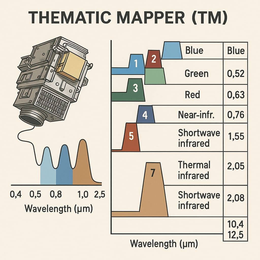
Hyperspectral Sensor Optical Sensors divided into 3 basic classes: Panchromatic, Multispectral, and Hyperspectral. Multispectral Sensor typically collects a few, wide (100-200 nm), and possibly noncontiguous spectral bands. Hyperspectral sensors typically collect hundreds of narrow (5-20 nm) contiguous bands. The name hyperspectral implies that the spectral sampling exceeds the spectral detail of the target. In practice, […]

Hyperspectral Imaging Read More »

Multispectral Imaging

Multispectral Imaging

Multispectral Imaging Sensor The Multispectral Scanner System (MSS) Sensor were line scanning devices observing the Earth perpendicular to the orbital track. The cross-track scanning was accomplished by an oscillating mirror; six lines were scanned simultaneously in each of the four spectral bands for each mirror sweep. The forward motion of the satellite provided the along-track

Multispectral Imaging Read More »

Thematic Mapper

Thematic Mapper

Summary: – The Thematic Mapper (TM) is a multispectral scanning sensor that was introduced aboard the Landsat 4 and Landsat 5 satellites. The TM sensor captures imagery in seven spectral bands, with a spectral and spatial resolution. Thematic Mapper Sensor: Landsat TM The Thematic Mapper (TM) is a powerful imaging sensor that was part of

Thematic Mapper Read More »

AWIFS Satellite image

AWIFS

AWIFS Sensor IRS (Indian Remote Sensing) AWIFS full form is; Advanced Wide Field Sensor. Resolution The Advanced Wide Field Sensor provides Multispectral data in 4 Bands. The Spatial Resolution (56 m vs 188 m), Spectral Bands (10 bits vs 7 bits) and Radiometric Resolution (4 vs 2). The ground swath of 740 kms (combined) and

AWIFS Read More »

LISS 3 Satellite image

LISS 3

LISS 3 Sensor IRS (Indian Remote Sensing) LISS 3 full form is; Linear Imaging Self-Scanning Sensor 3. LISS-III Resolution The LISS –III Sensor provides Multispectral data in 4 Bands. The Spatial Resolution for visible is 2 bands, and Near-Infrared 1 band is 23.5 meters with a ground swath of 141 kms. The short wave infrared

LISS 3 Read More »

Scroll to Top