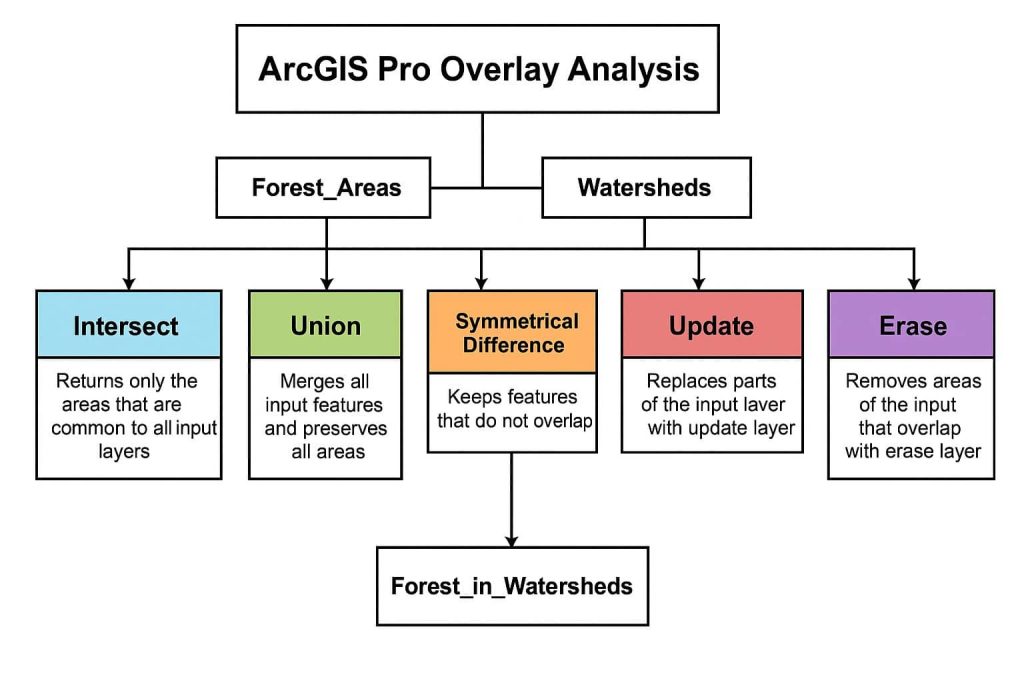
GISRSStudy » ArcGIS Pro » Page 2

ArcGIS Pro

ArcGIS Pro is the latest professional desktop GIS application from Esri

ArcGIS Pro, you can explore, visualize, and analyze data; create 2D maps and 3D scenes.

In below List of ArcGIS Pro Tutorial.

Georeferencing ArcGIS Pro

Georeferencing in ArcGIS Pro There are four steps to Georeference your data in ArcGIS Pro: Georeferencing Tools The Georeference tab contains all the tools you need to georeference your raster datasets. Georeferencing Options To access all the Georeferencing options, click the Options button, next to Alignment on the Imagery tab. Options Description From Symbol Edit […]

Georeferencing ArcGIS Pro Read More »

Overlay Analysis ArcGIS Pro

ArcGIS Pro Overlay Analysis Overlay analysis in ArcGIS Pro is a technique for applying a common scale of values to diverse and dissimilar inputs to create an integrated analysis. The are two methods for performing overlay analysis— Overlay Tools & Toolset he Overlay toolset contains tools to overlay multiple Feature classes. Tool Description Apportion Polygon

Overlay Analysis ArcGIS Pro Read More »

ArcGIS Pro Dissolve

Dissolve in ArcGIS Pro Use the Dissolve tool when you want to aggregate features based on a specified attribute or attributes. Dissolve creates the sales regions by removing the boundaries between counties represented by the same salesperson. An alternate tool is available for dissolve operations is the Pairwise Dissolve tool. Create a Dissolve in ArcGIS

ArcGIS Pro Dissolve Read More »

ArcGIS Pro Image Analyst

ArcGIS Pro Image Analyst ArcGIS Image Analyst for ArcGIS Pro provides tools for advanced image interpretation, exploitation, and geospatial analysis on an array of imagery modalities. Image Analyst Extension The ArcGIS Pro Image Analyst extension provides functions, tools, and capabilities for image and geospatial analysis focus on: Image Analyst Toolbox The ArcGIS Pro Image Analyst

ArcGIS Pro Image Analyst Read More »

ArcGIS Pro Hillshade

Hillshade in ArcGIS Pro Introduction Applying a Hillshade effect in ArcGIS Pro is quick, easy, and efficient to uses a raster function instead of a Geoprocessing tool. Hillshades enhance the three-dimensional appearance of the Terrain by using patterns of light and shadow to create a 3D representation of the Surface. To create this effect, you

ArcGIS Pro Hillshade Read More »

Scroll to Top