GIS Project Ideas
INTRODUCTION
Project Overview
GIS technology and systems have increased in popularity and interest over the past years. A GIS is a powerful tool for creating, managing, analyzing, and using Geospatial data. It can provide the huge benefit and growth of the future.
In this project, will design and execute a complete GIS-based analysis. Also, Data analysis is in line with project objectives. Interpret and explain the results obtained in comparison
For this Project Using ArcGIS and Erdas Imagine Software for creating maps and data.
Keywords: Image Rectification, Image Enhancement, Image Transformation, R to V conversion(Shapefile), Image classification, Density Analysis.
Location of the Study Area
Kolkata at a Glance
Calcutta/Kolkata stands on the Eastern Bank of the River Ganga. The tail end of the river Ganga flows by the side of Kolkata before it reaches Bay of Bengal about 180 Km. down stream from Kolkata. The Vital Statistics of a capital city, called by the British Raj as The Jewel of the East, and remained its capital till 1911, Kolkata is now the capital of West Bengal, a state of India.
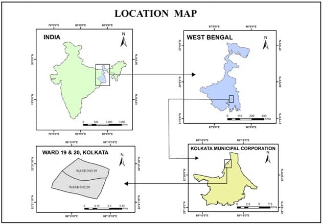
Location: Kolkata is situated at the longitude of 88º 30’E-22º 33′ N.
Altitude: 9m (30’). From sea level, it is 6.4 meters (20 ft). (Mount Everest 8848m.)
Climate: Maximum temperature rises during the summer months of May-June up to 24–42º C and the minimum temperature falls during the winter months of December–January up to 8–26ºC on an average. Climate is humid, varying from 85 to 65 during the summer & exceeding by pleasant in winter. From June to September, the average rainfall in Kolkata is 158 cm.
Area
Old Kolkata: Sutanuti—Chitpur, Baghbazar, Sobhabazar & Hatkhola.
Kolkata—Dharmatala, Bowbazar, Simla, Janbazar.
Gobindapur—Hastings, Maidan & Bhowanipur
New Kolkata: North—Sinthi, Cossipore & Gughudanga.
South—Tollygunge, Khidderpore & Behala.
East—SaltLake, Beliaghata & Topsia.
West—Hooghly river.
Greater Kolkata: Baruipur to Bansberia & Kalyani to Budge Budge.
Area in kilometers: 1480 sq. km. (London 1580 sq. km.) 205 sq. km. is within Corporation Area.
Population: A growing population of 45,80,544 according to 2001 Census. (Mumbai 14.8 million.)
Density of Population: 24.760/ sq. km.
Ratio of Population: Male—1000; Female—956;
Literacy Rate: 81.31%
Mother Tongues: Bengali 55%, Hindi 20%, English 10%, Others 15%
Position : 7th biggest city in India of area and population.
Kolkata Municipal Corporation (KMC) : The Kolkata Municipal Corporation (KMC) is responsible for providing basic civic services such as Roads, Lighting, Water Supply, Education, Health,etc to the people of Kolkata.
KMC takes pride in managing this Herculean task in the city, having a 10 million (resident and floating combined) population. KMC is responsible for supplying 350 MGD to 5 million people, clearing 4000 MT of solid waste per day, managing 136 clinics and 119 health units and running 358 primary educational schools with more than 40,000 students. In the last few years, KMC has brought about a phenomenal change in Kolkata by up-gradation of basic infrastructure, revamping inefficient administrative processes and introducing some innovative strategies for improved delivery of citizen services.
Objective
- Find out the vegetation cover of each ward.
- Measurement of vegetative and non-vegetative area.
- Find out variation of vegetation of study area.
- Find out the population density and vegetation density of the study area.
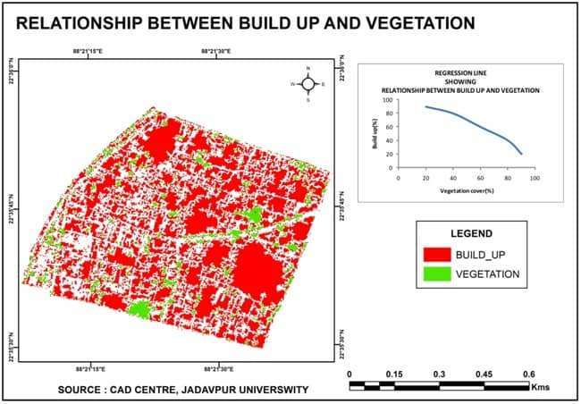
- Analysis of the relationship between vegetation and build up.
- Find out the road types, footpath facilities and other amenities.
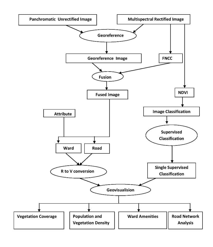
Methodology
The study report has been prepared using the information provide by GIS RS STUDY Organization through the spatial and attribute data .the project has done using the GIS Software (ArcGIS 10.3), and Remote Sensing Software (ERDAS 2014). Some other software use to- Ms-Access Database (2007). Ms-Ward (2007), Ms-Excel (2007) and paint software.
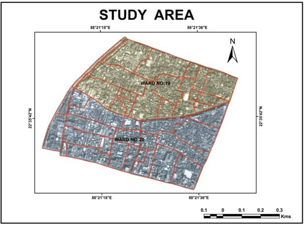
STUDY AREA OF THE PROJECT
Introduction to the Study Area
The Kolkata Municipal Corporation (KMC) total ward is 141, my project study area, ward no. 19 and 20 is in the North–West part of Kolkata, on the left bank of the hoogly river.
- Geographical location- This study area’s latitude is 22°35’42” North and longitude 88°21’27” East.
- Area- Total area of the study area is 0,52sq. km, differently ward no.19 is 0.23 sq.km and ward no.20 is 0.29 sq.km.
- Population- According to the 2001 census population in ward no.19 is 24,467 and ward no.20 is 19,486
- Roads and railway- These two wards are connected all over kokata wilh road and railway. Some main roads are of this area Sovabazar Street, B.K. Pal Avenue, Rabindra Sarani, Ahiritola Street, Stand Bank Road etc. Circular Railway (sovabazar ahiri railway station) and Metro Railway (sovabazar sutanuti metro station) has present both of wards.
- River- Hoogly is an only river in Kolkata, which is a tributary of the Ganga river. Both of wards situated western side of Hoogly River.
ANALYSIS and INTERPRETATION
Download PDF the Analysis and Interpretation chapter.
CONCLUSION and ANNEXURE
Conclusion
Thus we come to the final end of the project report where we can conclude the both wards of our study area are very congested and vegetation is very low, because our study area is under town area.
Now we can perform vegetation cover is decreasing day by day and has become a matter of immense concern. We have shown how, with the help of GIS, the affected area can be easily detected. So can extract that bigger name of our city will spend money and detect the affected area will try to improve it by planting as much as possible. Save trees are not for the human beings then for they cannot even speak for themselves.
To add to the deplorable condition of vegetation cover, the area is very densely polluted with narrow roads, making it highly populated and accident prone. Thus, attention should be given to the roads in this area, which are neither wide enough not have a footpath facility.
Annexure
Ward Table
| WARD NO | MARKET COMPLEX | UNDER GROUND HYDRANT | HERITAG BUILDING | POPULATION 2001 |
|---|---|---|---|---|
| 19 | 0 | 0 | 1 | 24467 |
| 20 | 1 | 1 | 2 | 19486 |
Road Table
| Sec ID | STREET NAME | CARRIAGE WIDTH | ROAD TYPE | LEFT FOOTPATH | RIGHT FOOTPATH | WARD NO |
|---|---|---|---|---|---|---|
| 1 | Stand Road | 9.30 | Bituminous | N | N | 20 |
| 2 | Maharsi Dedendra Road | 9.10 | Bituminous | N | N | 20 |
| 3 | Maharsi Dedendra Road | 9.10 | Bituminous | N | N | 20 |
| 4 | Kashi Dutta Street | 6.30 | Bituminous | N | N | 20 |
| 5 | Mahammod Romjan Lane | 2.30 | Stone Set | N | N | 20 |
| 6 | Mahammod Romjan Lane | 2.30 | Stone Set | N | N | 20 |
| 7 | Duttapara Lane | 5.90 | Bituminous | N | N | 20 |
| 8 | Kashi Dutta Street | 6.30 | Bituminous | N | N | 20 |
| 9 | Butto Kristo_Paul Avenue | 16.00 | Bituminous | Y | Y | 20 |
| 10 | Nimtola Ghat Street | 12.30 | Bituminous | Y | Y | 20 |
| 11 | Nimtola Ghat Street | 12.30 | Bituminous | Y | Y | 20 |
| 12 | Gopi Krishna Paul Lane | 3.30 | Bituminous | N | N | 20 |
| 13 | Butto Kristo Pual Avenue | 16.00 | Bituminous | Y | Y | 20 |
| 14 | Baburam Ghose Lane | 3.00 | Bituminous | N | N | 20 |
| 15 | Nimo Gossain Lane | 2.90 | Bituminous | N | N | 20 |
| 16 | Gour Laha Street | 5.00 | Bituminous | N | N | 20 |
| 17 | Gopi_Krishna_Paul_Lane | 3.30 | Bituminous | N | N | 20 |
| 18 | Kaliprossanna_Banerjee_Road | 4.70 | Bituminous | N | N | 20 |
| 19 | Brindaban_Basak_Street | 5.40 | Bituminous | N | N | 20 |
| 20 | Ahiritola_Street | 6.10 | Bituminous | Y | Y | 20 |
| 21 | Butto Kristo PaulAvenue | 16.00 | Bituminous | Y | Y | 20 |
| 22 | Manick Bose’s Ghat Street | 4.00 | Stone Set | N | N | 20 |
| 23 | Kshirode Gopal Mitra Lane | 2.40 | Stone Set | N | N | 20 |
| 24 | Manick Bose’s Ghat Street | 4.00 | Stone Set | N | N | 20 |
| 25 | Maharsi Debendra Road | 9.10 | Bituminous | N | N | 20 |
| 26 | Maharsi Debendra Road | 9.10 | Bituminous | N | N | 20 |
| 27 | Maharsi Debendra Road | 9.10 | Bituminous | N | N | 20 |
| 28 | Darmahatta 1st Lane | 2.60 | Stone Set | N | N | 20 |
| 29 | Maharsi Debendra Road | 9.10 | Bituminous | N | N | 20 |
| 30 | Manick Bose’s Ghat Street | 4.00 | Stone Set | N | N | 20 |
| 31 | Strand Bank Road | 9.10 | Bituminous | N | N | 20 |
| 32 | Rabindra Sarani | 9.80 | Bituminous | Y | N | 20 |
| 33 | Kashi Dutta Street | 6.30 | Bituminous | N | N | 20 |
| 34 | Maharsi Debendra Road | 9.10 | Bituminous | N | N | 20 |
| 35 | Sovabazar Street | 8.40 | Bituminous | N | N | 19 |
| 36 | Rabindra Sarani | 9.80 | Bituminous | Y | N | 19 |
| 37 | Butto Kristo Paul Avenue | 16.0 | Bituminous | Y | Y | 19 |
| 38 | Sovabazar Street | 8.40 | Bituminous | N | N | 19 |
| 39 | Butto Kristo Paul Avenue | 16.0 | Bituminous | Y | Y | 19 |
| 40 | Nather Bagan Bye Lane | 4.70 | Bituminous | N | N | 19 |
| 41 | Ahiritola 1st Lane | 4.30 | Bituminous | N | N | 19 |
| 42 | Ahiritola 1st Lane | 4.30 | Bituminous | N | N | 19 |
| 43 | Ahiritola Street | 5.50 | Bituminous | N | N | 19 |
| 44 | Ahiritola Street | 5.50 | Bituminous | N | N | 19 |
| 45 | Nather Bagan Lane | 4.80 | Stone Set | N | N | 19 |
| 46 | Bhagaban Banerjee Lane | 3.30 | Bituminous | N | N | 19 |
| 47 | Nather Bagan Lane | 4.80 | Bituminous | N | N | 19 |
| 48 | Beniatola Street | 5.30 | Bituminous | N | N | 19 |
| 49 | Sen Lane | 4.80 | Bituminous | N | N | 19 |
| 50 | Beniatola Street | 5.30 | Bituminous | N | N | 19 |
| 51 | Baroaritola Lane | 5.00 | Bituminous | N | N | 19 |
| 52 | Beniatola Street | 5.30 | Bituminous | N | N | 19 |
| 53 | Sonar Gouranga Temple Street | 4.90 | Bituminous | N | N | 19 |
| 54 | Sashi Sur Lane | 2.20 | Bituminous | N | N | 19 |
| 55 | Beniatola Street | 5.30 | Bituminous | N | N | 19 |
| 56 | Ram Pal Lane | 3.00 | Bituminous | N | N | 19 |
| 57 | Ahiritola 2nd Lane | 5.10 | Bituminous | N | N | 19 |
| 58 | Ahiritola 2nd Lane | 5.10 | Bituminous | N | N | 19 |
| 59 | Ram Pal Lane | 3.00 | Bituminous | N | N | 19 |
| 60 | Haradhole Lane | 3.00 | Bituminous | N | N | 19 |
| 61 | Sankar Halder Lane | 4.90 | Bituminous | N | N | 19 |
| 62 | Strand Bank Road | 7.00 | Bituminous | N | N | 19 |
| 63 | Sovabazar Street | 8.40 | Bituminous | N | N | 19 |
| 64 | Butto Krishno Paul Avenue | 16.00 | Bituminous | Y | Y | 19 |
| 65 | Gopi Krishna Paul Lane | 3.30 | Bituminous | N | N | 20 |
| 66 | Gopi Krishna Paul Lane | 3.30 | Bituminous | N | N | 20 |
| 67 | Ahiritola Bye Lane | 2.10 | Stone Set | N | N | 20 |
| 68 | Sovabazar Street | 8.40 | Bituminous | N | N | 19 |
| 69 | Sovabazar Street | 8.40 | Bituminous | N | N | 19 |
| 70 | Butto Krishno Paul Avenue | 16.00 | Bituminous | Y | Y | 19 |
| 71 | Butto Krishno Paul Avenue | 16.00 | Bituminous | Y | Y | 19 |
| 72 | Butto Krishno Paul Avenue | 16.00 | Bituminous | Y | Y | 19 |
| 73 | Ahiritola Street | 5.50 | Bituminous | N | N | 19 |
| 74 | Ahiritola Street | 5.50 | Bituminous | N | N | 19 |
| 75 | Ahiritola Street | 5.50 | Bituminous | N | N | 19 |
| 76 | Maharsi Debendra Road | 9.10 | Bituminous | N | N | 19 |
| 77 | Maharsi Debendra Road | 9.10 | Bituminous | N | N | 19 |
| 78 | Maharsi Debendra Road | 9.10 | Bituminous | N | N | 19 |
| 79 | Ahiritola Street | 5.50 | Bituminous | N | N | 19 |
| 80 | Beniatola Street | 5.30 | Bituminous | N | N | 19 |
| 81 | Nather Bagan Street | 3.00 | Bituminous | N | N | 19 |
| 82 | Ramdhan Khan Lane | 4.30 | Bituminous | N | N | 19 |
| 83 | Nather Bagan Street | 3.00 | Bituminous | N | N | 19 |
| 84 | Bhagaban Banerjee Lane | 3.30 | Stone Set | N | N | 19 |
| 85 | Beniatola Street | 5.30 | Bituminous | N | N | 19 |
| 86 | Sankar Halder Bye Lane | 2.20 | Bituminous | N | N | 19 |
| 87 | Sankar Halder Bye Lane | 2.20 | Bituminous | N | N | 19 |
| 88 | Sankar Halder Lane | 4.90 | Bituminous | N | N | 19 |
| 89 | Sonar Gouranga Temple Street | 4.90 | Bituminous | N | N | 19 |
| 90 | Beniatola Street | 5.30 | Bituminous | N | N | 19 |
| 91 | Beniatola Street | 5.30 | Bituminous | N | N | 19 |
| 92 | Sovabazar Street | 8.40 | Bituminous | N | N | 19 |
| 93 | Rabinra Sarani | 9.80 | Bituminous | Y | N | 20 |
| 94 | Rabinra Sarani | 9.80 | Bituminous | Y | N | 20 |
| 95 | Rabinra Sarani | 9.80 | Bituminous | Y | N | 20 |
| 96 | Nimtola Ghat Street | 12.30 | Bituminous | Y | Y | 20 |
| 97 | Nimtola Ghat Street | 12.30 | Bituminous | Y | Y | 20 |
| 98 | Gour Lah Street | 5.00 | Bituminous | N | N | 20 |
| 99 | Nimtola Ghat Street | 12.30 | Bituminous | Y | Y | 20 |
| 100 | Nimtola Ghat Street | 12.30 | Bituminous | Y | Y | 20 |
| 101 | Strand Road | 11.30 | Stone Set | Y | Y | 20 |
| 102 | Strand Bank Road | 9.10 | Bituminous | N | N | 20 |
| 103 | Madan Mohon Dutta Lane | 4.60 | Bituminous | N | N | 20 |
| 104 | Duttapara Lane | 5.90 | Bituminous | N | N | 20 |
| 105 | Manick Bose’s Ghat Street | 4.00 | Stone Set | N | N | 20 |
| 106 | Mothur Sen’s Garden Lane | 3.10 | Bituminous | N | N | 20 |
| 107 | Butto Kristo Paul Avenue | 16.00 | Bituminous | Y | Y | 20 |
| 108 | Nimo Gossain Lane | 2.90 | Bituminous | N | N | 20 |
| 109 | Nimo Gossain Lane | 2.90 | Bituminous | N | N | 20 |
| 110 | Brindaban Basack Street | 5.40 | Bituminous | N | N | 20 |
| 111 | Nimtola Ghat | 4.00 | Bituminous | N | N | 20 |