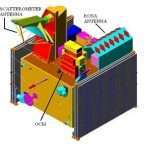
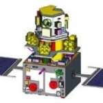
CartoSat Satellite
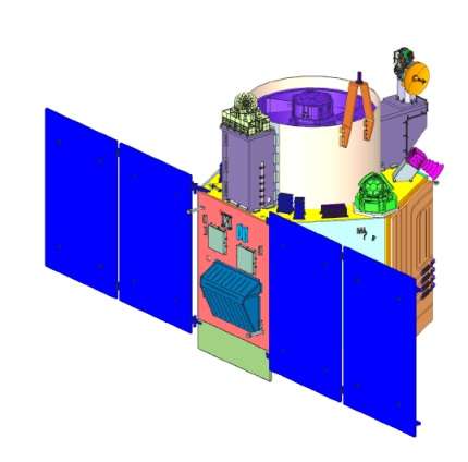
The Cartosat satellites is a Indian optical earth observation satellites and operated by the Indian Space Research Organisation (ISRO). They are used for Earth’s resource management, defence services and monitoring.
Oceansat Satellite Specification:
- Country of origin – India
- Manufacturer – ISRO
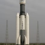
- Launched – PSLV-C6
- Weight – 700–1600 kg
- Orbit – 618 km
- Placed – Polar Sun Synchronous
- Equipment – Panchromatic cameras
CartoSat Satellites Series
| Satellite | Resolution (m) | Power | Launch date, Time (UTC) | Launch mass | Launch vehicle | Launch site |
|---|---|---|---|---|---|---|
| Cartosat-1 | 2.5 | 1100 W | 5 May 2005, 04:44 | 1,560 kg (3,440 lb) | PSLV-G C6 | SLP, SDSC |
| Cartosat-2 | < 1 | 900 W | 10 January 2007 , 03:57 | 680 kg (1,500 lb) | PSLV-G C7 | FLP, SDSC |
| Cartosat-2A | 900 W | 28 April 2008, 03:54 | 690 kg (1,520 lb) | PSLV-CA C9 | SLP, SDSC | |
| Cartosat-2B | 930 W | 12 July 2010, 03:52 | 694 kg (1,530 lb) | PSLV-CA C15 | FLP, SDSC | |
| Cartosat-2C | 1.2 | 986 W | 22 June 2016, 03:56 | 727.5 kg (1,604 lb) | PSLV-XL C34 | SLP, SDSC |
| Cartosat-2D | 986 W | 15 February 2017, 03:58 | 712 kg (1,570 lb) | PSLV-XL C37 | FLP, SDSC | |
| Cartosat-2E | 986 W | 23 June 2017, 03:59 | 712 kg (1,570 lb) | PSLV-XL C38 | FLP, SDSC | |
| Cartosat-2F | 986 W | 12 January 2018, 03:59 | 710 kg (1,570 lb) | PSLV-XL C40 | FLP, SDSC | |
| Cartosat-3 | 0.25 | 2000 W | 27 November 2019, 03:58 | 1,625 kg (3,583 lb) | PSLV-XL C47 | SLP, SDSC |
CartoSat-1
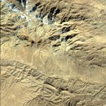
Cartosat-1 is the first Indian Remote Sensing Satellite of providing in-orbit stereo images. It’s provided stereo pairs required for generating Digital Elevation Model‘s(DEM), Ortho Image products, and Value added products for various applications of Geographical Information System (GIS).
CartoSat-1 Specification
| Launch date | 5 May 2005 |
| Launch site | SHAR, Sriharikota India |
| Launch vehicle | PSLV- C6 |
| Orbit | Polar Sun Synchronous |
| Altitude | 618 km |
| Payloads | PAN FORE, PAN – AFT |
| Orbit Period | 97 min |
| Number of Orbits Per day | 14 |
| Local time of equator crossing | 10:30 am |
| Repetivity | 126 days |
| Revisit | 5 days |
| Lift-Off mass | 1560 kg |
| Power | 15 sq.m Solar Array generating 1100w, Two 24 Ah Ni-Cd batteries |
| Mission life | 5 years |
CartoSat-2
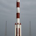
Cartosat-2 Series Satellite is the primary satellite carried by PSLV-C40. This remote sensing satellite is similar in configuration to earlier satellites in the series and is intended to augment data services to the users.
The satellite will be useful for Cartographic applications, Urban and Rural applications, Coastal land use and regulation, utility management like road network monitoring, water distribution, creation of land use maps, and other land information system.
CartoSat-2 Specification
| Launch date | 12 Jan, 2018 |
| Launch site | SHAR, Sriharikota India |
| Launch vehicle | PSLV-C40 |
| Orbit | Polar Sun Synchronous |
| Altitude | 630 km |
| Orbit Period | 97 min |
| Number of Orbits Per day | 14 |
| Local time of equator crossing | 9:30 am |
| Repetivity | 310 days |
| Revisit | 5 days |
| Lift-Off mass | 710 Kg |
| Mission life | 5 years |
CartoSat-2A
Cartosat-2A was launched by PSLV-C9 on 28 April 2008 from Satish Dhawan Space Centre in Sriharikota. The satellite carries a panchromatic (PAN) camera.
It is a dedicated satellite for the Indian Armed Forces which is in the process of establishing an Aerospace Command.
CartoSat-2B
Cartosat-2B was launched by PSLV-C15 on 12 July 2010 from Sriharikota. The satellite is the seventeenth satellite in the Indian Remote Sensing (IRS) satellite series.
CartoSat-2C
Cartosat-2C was launched on board PSLV C-34 during 2014. The satellite has a lower resolution of 25 cm. It’s uses include weather mapping, cartography, and strategic applications.
CartoSat-2D
Cartosat-2D was launched by PSLV-C37 on 15 February 2017 from Satish Dhawan Space Centre.
CartoSat-2E
Cartosat-2E was launched by PSLV-C38 on 23 June 2017. It is designed to collect high-resolution, large-scale imagery for use in urban planning, infrastructure development, utilities planning, and traffic management.
CartoSat-2F
Cartosat-2F was launched successfully by PSLV-C40 on 12 January 2018.
CartoSat-3
Cartosat-3 satellite is a third generation agile advanced satellite having high resolution imaging capability. The satellite was launched on 27 November 2019 by PSLV-C47 rocket along with 13 other cubesats from USA.
It has a panchromatic resolution of 0.25 metre, and maxium of 1 metre with a high quality resolution which is a major improvement from the previous payloads in the Cartosat series.
CartoSat-3 Specification
| Launch date | 27 Nov, 2019 |
| Launch site | SHAR, Sriharikota India |
| Launch vehicle | PSLV-C47 |
| Orbit | Polar Sun Synchronous |
| Altitude | 509 km |
| inclination | 97.5° |
| Revisit | 5 days |
| Lift-Off mass | 1625 kg |
| Power Generation | 2000W |
| Mission life | 5 years |