Create Utility Network in ArcGIS
At present situation utilities need actionable information to support complex networks. No matter what your industry, utilities need to provide a safe working environment, deliver reliable service, and maintain a focus on customer support.
ArcGIS Utility Network is designed to be the next generation spatial information system to provide greater functionality over massive datasets at every scale of resolution.
What is Utility Network?
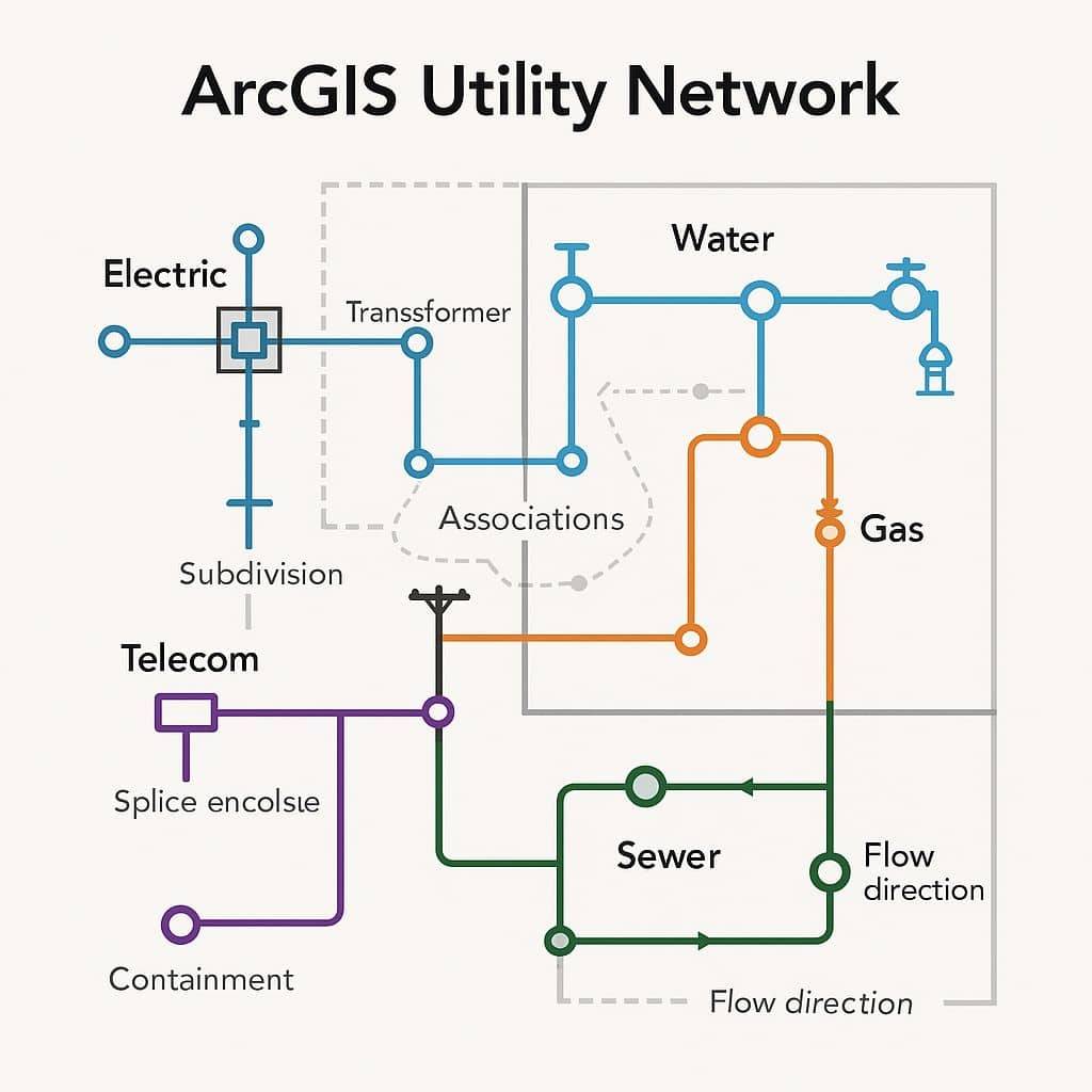
A utility network work with when managing utility and telecom networks in ArcGIS, providing a comprehensive framework of functionality for the modeling of utility systems such as; electric, gas, water, storm water, wastewater, and telecommunications.
It is designed to model all of the components that make up your system, such as wires, pipes, valves, zones, devices, and circuits, and allows you to build real-world behavior into the network features you model.
The utility network can be accessed with either an enterprise or single-user deployment:
- An enterprise deployment provides the richest capabilities of the utility network through a services-based architecture using ArcGIS Enterprise.
- A single-user deployment provides the full analytic capability of the utility network while hosted on a file or mobile Geodatabase.
Features
- Discover how features and objects in the network are connected.
- Create and edit features and objects that model every type of utility equipment.
- Trace how resources, such as gas, water, and electricity, flow through the network.
- Provide an operational view of how all the dynamic devices of your utility are currently configured.
- Analyze how the network is affected by real-world events such as storms, outages, or equipment failure.
Benefits
- More accurate and scalable network representation.
- Streamlined data workflows and real-time editing.
- Integration with ArcGIS Field Maps, Dashboard, Survey123, etc.
- Improved decision-making through advanced tracing and visualization.
How Its Works
Create a Utility Network in ArcGIS Pro
The Utility Network tool is used to create a utility network in the specified geodatabase feature dataset.
To create a utility network in an enterprise geodatabase, the database platform must meet the minimum release in the table below:
| Database platform | Minimum release |
|---|---|
| SQL Server | SQL Server 2016 |
| Oracle | Oracle 19.3.0.0 |
| PostgreSQL | PostgreSQL 11.15 |
| SAP HANA | HANA 2.0 SPS 05 |
Create Utility Network in a Geodatabase
Steps:
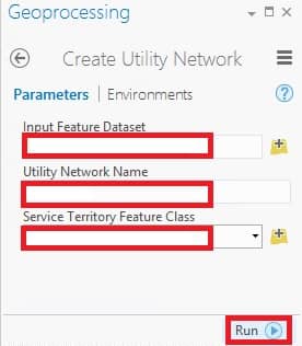
1. On the Analysis tab, in the Geoprocessing group, click Tools  to open the Geoprocessing pane.
2. In the Geoprocessing pane, search and select Create Utility Network.
3. For Input Feature Dataset, browse to an existing feature dataset  in your geodatabase.
3. Specify a name for the Utility Network Name parameter.
4. Specify a polygon feature class  for the Service Territory Feature Class parameter.
5. Click Run to run the tool.