GeoPlanner for ArcGIS
Table of Contents
What is GeoPlanner?
ArcGIS GeoPlanner is a application for Geo-design and scenario planning, that keeps the pulse on the environmental impact for new or existing designs. Its helps communicate design intent while balancing environmental constraints.
Features of GeoPlanner
- GeoPlanner provides a design framework and supporting technology for professionals to leverage geographic information.
- It is a collaborative set of tools. You can work simultaneously with others on plans and designs or share items, including web maps, feature layers, and data exports.
- GeoPlanner supports a complete planning workflow from project creation to report generation.
GeoPlanner Tutorial
Once you have signed in to the app, you’ll be prompted to create a new project.
Project settings
Click the Open Menu button of the app to display the project settings.
Tools available Tools in GeoPlanner :
- Info—Access and edit project properties and invite a user to the project team.
- Save—Save the project.
- Open—Open an existing project.
- Create—Create a new project.
- Attachment—Discover files, like- .pdf, .docx, and so on, shared with the project group or your organization.
- Export—Export your web map and scene.
- Export Web Map—Export your web map and save it in your ArcGIS organizational account. This allows you to access your scenarios, designs, or plans in a story, Web AppBuilder app, or any other ArcGIS software.
- Export Web Scene—Export your 3D content and save it in your ArcGIS organizational account. This allows you to share your 3D content with others using Scene Viewer.
- Collaborate—Tools that allow collaboration with users during the planning and sharing process.
- Update Project Defaults—Share your current web map with anyone who is collaborating with you on a project.
- Reset Project—Refresh your current web map with the content, layers, and dashboard that others have shared through the project web map.
- Save as Template—Save your current project as a template, so you can create new projects using the layers, dashboard, and other settings you’ve created in your project.
- Print—Export the current map to a .pdf file and other image formats.
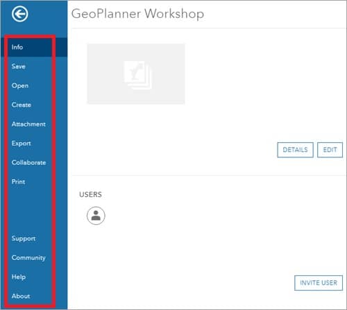
Other tools are;
- Support—you can connect to the GeoPlanner support team for any query.
- Community—in the community tab, communicate with other users to share the experience used by GeoPlanner.
- Help—this tool helping you to how to use GeoPlanner.
- About—GeoPlanner app information.